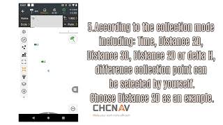
how to do set slope stakeout with chcnav i89 pocket visual rtk and landstar 8 software?
Published 7 months ago • 1.3K plays • Length 1:21Download video MP4
Download video MP3
Similar videos
-
 1:21
1:21
how to do slope stakeout with chcnav gnss rtk and landstar 8 software
-
 1:22
1:22
measurement and stakeout — how to use chcnav landstar8 for surface stakeout?
-
 1:02
1:02
measurement and stakeout — how to use chcnav gnss rtk for point stakeout?
-
 1:54
1:54
measurement and stakeout — how to use chcnav gnss rtk for line stakeout?
-
 2:45
2:45
let's see how to do site calibration with chcnav gnss rtk and landstar software? #tutorials #survey
-
 1:16
1:16
measurement and stakeout — how to use chcnav gnss rtk for control survey?
-
 1:56
1:56
how set up landstar in the lt800h tablet before surveying? #gnss #survey #geography #tablet
-
 14:14
14:14
chcnav i93 tutorial in telugu
-
 32:11
32:11
dgps survey practical by rtk method using chcnav i50/i80 dgps
-
 0:34
0:34
basic introduction — how to use the base shift function of chcnav landstar8?
-
 2:23
2:23
chcnav landstar 8 - device connection
-
 2:28
2:28
measurement and stakeout——how to use chcnav gnss rtk for continuous survey?
-
 2:53
2:53
chcnav landstar 8 - road stakeout profiles
-
 0:51
0:51
how to modify the quick codes in batches with chcnav landstar 8 software!
-
 4:46
4:46
chcnav landstar 8 - start an auto base using landstar 8
-
 3:29
3:29
how to use chcnav gnss rtk for radio base-rover surveying.#chcnav #gnss #rtk #landscape #surveying
-
 1:01
1:01
how surveyors use this chcnav gnss receiver!#surveyors #gnssreceiver #chcnav #gnss #gps
-
 0:47
0:47
basic introduction — how to use chcnav gnss rtk for site calibration?